Showing posts with label Pacific Crest Trail. Show all posts

Saturday, November 14, 2015

Numbers

By Tyler Socash
IG: @tylerhikes

Numbers never lie.  I have compiled all of the interesting statistics that I could think of regarding my thru-hike.  These are objective facts based on my 2015 SOBO journey.  Use this information at your own risk, and by that I mean get outside into a park near you pronto!
 
2,650.1 - Total distance in miles of the Pacific Crest Trail according to the Halfmile maps. (Slightly longer than 101 marathons, and you all remember your first marathon!...)

488,411 - Total PCT vertical gain in feet while trekking those 101 marathons southbound to Mexico.  (Equivalent to nearly 17 ascents of Mt. Everest if starting from sea level.) 
This number is also from the Halfmile maps. https://www.pctmap.net/2014/03/elevation-gain-on-the-pacific-crest-trail/

I only saw 2 PCT trail markers during the first 60 miles of hiking. 

122 - Number of days that it took me to hike from monument to monument, Canada to Mexico. (June 27 - October 26, just under 4 months!  The average PCT thru-hike lasts 5 months.)

21.72 - Average number of miles hiked per day including time spent in town.  Honest math. 

4,003 - Average vertical ascent in feet per day.  That's a lot of climbing! 

3 - Pairs of Vasques boots used on the entire Pacific Crest Trail.  I also used 6 pairs of socks.

Two-thirds of my hiking footwear. 

5 - Number of trail names that I gave to other PCT hikers.  I was hoping to report back with 6 but "Talent Boy" didn't want to keep his name. 

6 - Age of the youngest person to complete the PCT, "Buddy."

76 - Age of the oldest person who I hiked with this year.  Hiking is a great lifetime sport! 

27 - Number of towns that I visited in order to resupply myself with provisions.

101.1 - Miles from Barrel Spring to the Mexican border.  This would be the longest natural-source waterless stretch for southbounders on the Pacific Crest Trail.  This is one of the main reasons why going northbound is so popular — more streams are running from snowmelt in the early Spring.  Don't worry, there are spigots and water caches along the way, but this trail would be extremely difficult without these luxuries.  Another daunting natural waterless stretch for southbounders was from Spanish Needle Creek to Robin Bird Spring, 67.9 miles.  Yes, Joshua Tree Spring is in-between, but that water is laced with uranium.  These desert distances make Oregon's 33.1-mile stretch between Thielsen Creek and Lightning Spring seem easy!  I also once thought Washington's 12-mile dry stretch around Grizzley Peak was tough!  Look how far I've come!  Rule of thumb: Fill up when water is available.  Hiking southbound was nice because by the time I got to the long waterless stretches down south I was in the best shape of my life. 

This water cache in the San Felipe Hills helps everyone out!  Thank you Trail Angels!

54 - Longest hiking distance in miles that I hiked in one day.  This stretch was from a site just south of Tehachapi Pass to Pine Canyon Road over the L.A. Aqueduct with the Wrong Way Gang.  This was one of my two double marathon days. 

14,505 - Highest elevation in feet reached on this trip.  This was an 16-mile detour to climb Mt. Whitney, California's highest peak.  The highest point on the actual PCT is Forester Pass at 13,200ft. 

140 - Lowest elevation in feet reached on this trip.  This was in Washington State near the Columbia River. 

Not many people celebrate at the PCT low point.  Here it is!

2 - Number of "zeros" that I took while hiking the PCT.  

3,500 - Cost in USD of my thru-hike, not including the plane tickets.  The average thru-hike costs between 4k-6k.  I would attribute my below average total to three things: the low number of zeros that I took, my completion speed, and having already owned hiking equipment.  New gear along the trail, resupplies, and town expenditures add up!  The secret to saving money... Don't spend the night in a town.  You already have your sleeping bag, and outside is free.  An overnight in town inevitably results in additional restaurant bills. Save some cash and donate to the lovely Trail Angels along the way instead!  

8 - Weight loss in pounds after completing the PCT. 

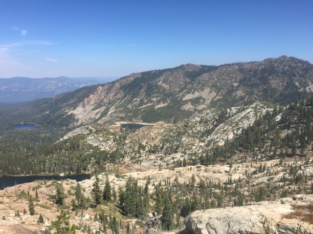
23 - Number of bodies of water that I swam in along the PCT.  This includes the three deepest lakes in the United States: Crater Lake, Lake Tahoe, and Lake Chelan.  I didn't count anything less than full submersion as a legit swim. 

Middle Rosary Lake, Oregon

5 - Number of black bears that I saw on the entire thru-hike.  All of the Bears ran away from me as fast as possible once they saw me.  There is no need to view this beautiful creature as an antagonist.  Bears are awesome, and I'm so happy that I saw them.

48 - Number of Wilderness areas along the PCT.  These places... Wow!

7 - Number of National Parks along the PCT.  Have you been to any of them?

2.7 - Remaining percentage of the continental U.S. protected as wilderness.  Hopefully you agree that this is a shockingly low percentage, considering that this country was nearly 100% wild a short time ago. Check www.wilderness.net 

20 - Degrees Fahrenheit that my down sleeping bag was rated for.  I was too warm most nights, but glad that I had it during the desert where I experienced the coldest temperatures.  I know, right?! "Don't you know the desert is hot?" said everyone. 

9 - Instances of precipitation while walking across Washington, Oregon, and California combined!  I imagine that total rainfall would be less than 3 days out of 122 days of thru-hiking.  I was told that this was the fourth terrible drought year in a row.  I'd expect more rain next time, especially if I went NOBO (it rains a lot in the Cascades come September).

90 - Number of nights spent cowboy camping under the stars. (The other nights: 1 in a hammock, 2 in tepees, 7 in a tent, 22 days under a roof!)

Cowboy camp set-up on Methow Pass in rugged Northern Washington.

At the OR/CA border. 

1,052.1 - Number of miles hiked without carrying a tent.  I shipped it from Cascade Locks, OR, to Echo Lake, CA to save on weight.  This was very foolish, but I just assumed it would never rain!  This means I hiked 40% of the PCT without a precipitation backup plan.  I was rained on twice during that tentless stretch — including the first night without my tent!

29 - Days that I hiked solo on the PCT.  People always ask me, "Were you alone most of the time?"  Nope, I hiked with others 76% of the time, which is probably a very high statistic for a southbound thru-hiker!  I also saw at least one other human being every single day during this thru-hike...  Maybe the trail isn't as Wild as you would hope?

56 - The highest number of northbound hikers who passed me in one day.  Everyone always wants to know where the dreaded NOBO herd is.  I encountered it on August 10th just south of Crater Lake. I met my first NOBO July 9th ("Magic," a super nice guy) in the Alpine Lakes Wilderness.  I was shocked to meet the last alleged NOBO thru-hiker on Septwmber 9th in the Carson-Iceberg Wilderness. I hope he makes it!  My friend Half Jesus is still out there on his SOBO journey.  Just like what Billy Goat says, "The last one to the border wins!  If you go fast, you get to the monument and say, 'Well I guess I'll go home now...'  People forget why they left their job to be out here in the first place!"

1,998 - Number of miles that I carried my bear canister... From the Canadian border to Walker Pass!  You need this piece of equipment in the High Sierra. 

0 - The number of times I went to dig a 6-8 inch cathole and accidentally dug up NOBO poop.  Phew!

10 - The number of Keystone Lights I consumed before throwing in the towel during the 24-24-24 Challenge.  Groucho was able to actually complete this mythical hiker quest.  I am still amazed. 

Groucho rocking the 12-packs in each hand. 

If you liked this Numbers post, you'll tolerate this Pacific Crest Trail Finale video... Look how far my beard has come! http://youtu.be/VUmAUZ2sWI8
Enjoy the monument celebration at the end :)

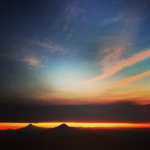
I'll admit that I got lucky with an unseasonably warm June, I got lucky with weather, and I was lucky to avoid most forest fire issues.  Next year might be totally different, so please go forth prepared.  Please follow all Leave No Trace ethics on your future hike, no matter the distance.  Let's do our part to keep our trails awesome!

- Future Dad

Monday, September 7, 2015

Trail Life Transcendentalism

By Tyler Socash
IG: @tylerhikes

"Trail Life, what's it all about?!  How is it different from life in the Real World?!"

First thought: nature is actually the real world.  Nowadays, we humans mainly exist in a modernized world.  This is completely fine, as I also love the comforts of the Internet and other ancillary services the Internet brings our civilization.  Lexical semantics aside, how is my thru-hike different from the life I left behind?  Surely, it is different.  "How so?"  I'll tell you! 

Hiking on the Pacific Crest Trail, any long-distance trail, requires work and dedication.  Much like a classic job, I feel like I'm at work all day!  It begins exactly the same in each world...  I wake up, and the sun rises in the east.  

Suddenly I'm reminded of subtle differences.  I automatically orient myself.  Birds are chirping.  Muscles and blisters ache (especially during the first month).  The sky is beautiful.  It's time to fill my pot with water.  Ignite the pocket rocket.  I really hope that I'm awake before my hiking companions so I don't have to rush.  Keep eyes closed while the water comes to a boil.  Consume oatmeal (100 days of oatmeal - not tired of it yet).  Remain in sleeping bag while the sun heats the part of the world that I happen to exist on.  Conclude oatmeal consumption (which also included bits of chocolate and crushed Pop-Tarts – I cannot withold such details). 

Deflate air out of Thermarest NeoAir sleeping pad.  Once the insulation is gone, you hit the point of no return.  You must get up.  Sometimes I can still see my breath.  Sometimes I'm too hot.  Either way, you can't hike in a 20-degree sleeping bag (read: any sleeping bag).  Begrudgingly remove clammy feet from sleeping bag.  Stuff sleeping bag into its proper sack.  Repeat with Thermarest pad.  Don we now our gay apparel.  By that I mean two things: socks and boots. 

Really quick... The Pacific Crest Trail, and possibly everything west of the Continental Divide, is so unbelievably dry.  Even arid.  I will one day (on the Appalachian Trail) pine for these mornings.  My feet never get wet out here. 

Clothing adjustments are made, and all sleeping materials are stored in their respective places in and on my Osprey backpack.  Cooking items and food are neatly crammed into their spots.  And I venture off having failed yet again to brush my teeth.  

This is probably when you expect me to talk about the views.  I can't do that yet because it's the morning and I'm in desperate need of locating my outdoor restroom.  Extract poop trowel (which I have named "Bette Midler") and toilet paper from pack.  Be discreet.  Find a spot far from trails and water sources.  Dig a 6-8 inch cathole.  What?... This is what you're reading this blog for, right?!  This is educational.  Also, you quickly realize that your bathroom view is phenomenal.  Crap, I wasn't supposed to mention the views yet!

Jumping back into the modernized world...  Wake up in a dark apartment.  Rub eyes and curse mildly.  You shouldn't have gone to Dragonfly last night.  Turn on shower.  Water magically appears. There's no need to step all the way in.  Just lean in, getting your hair damp enough so that the co-workers will think you actually took a proper shower, though we all know there's no time for that.  Utilize toilet that flushes excessive amounts of clean water down the drain.  You notice the views: floor tiles cracking, someone's hair collecting in lumps on the wall somehow, how many dead ladybugs are going to collect in the storm window prison? These views are sub-optimal.  Feign washing your hands because who's watching anyway?  Venture off downstairs after clumsily putting on dress clothes, having failed yet again to brush your teeth. 

Downstairs is a kitchen.  It can have anything you want in it.  You just have to buy it from Wegmans sometime that week.  Despite unlimited options, breakfast doesn't change too much over the course of your life.  Although you keep forgetting to buy Fruity Pebbles and there is a pang of regret as you throw last night's leftovers in a bag and sulk towards the door, understanding that breakfast will again consist of coffee at work anyway. 

Hiking world: The commute begins!  Crisp air.  More birds now, the chirping escalates.  Friends are ahead of you and behind you.  The path traveled is different than yesterday.  The commute is ever-changing, ever-stimulating.  Still heading towards an unfathomable goal far, far away.  The light overtakes the darkness.  You see it in canyon walls, on treetops, on distant mountains.  The sun, the big yellow celestial object that creates enough energy to power all chlorophyll-based plants on Earth and which will one day power the needs of our fossil fuel-dependent world, rises ever higher.  Stars seem to vanish.  You try to pick out a last constellation before daylight steals them away.  You notice Polaris getting lower in the sky as you progress southward.  Allow your mind to be blown as your realize you've walked more than 10 degrees of latitude towards the Equator.   You see animal tracks on the trail.  You see little mammals and plants beneath the old growth.  Everything is alive.  A mother grouse protects its chicks as you approach.  A mother doe teaches it's fawn how to hop away as you draw near.  You realize that animals have feelings.  You realize that your struggle to survive out here is like theirs, only you're wearing synthetics purchased from REI or from the Internet.  

"You're alive, the trees are living too!" - a hand-painted sign reads outside of Quincy, CA.  A 6th grader.  Smart kid. 

You're out of water.  You come to a spring.  It's a spring so you can probably drink it without filtering.  Sweet.  Little flowers that you've been seeing throughout this section of trail grow near the source.  It's always cold.  Tastes great. 

Back to the "Real World":  The commute sucks.  It sucks and it consumes your life.  Most Americans spend as much time in traffic per year as they spend time on vacation.  Surprise!  I walk to the bus stop and make it just in time.  We meander surface streets, seeming to miss every green light on the way.  You have no friends in front of you nor behind you.  Every human in their own box of steel is a hindrance to your free coffee at work. The freeway traffic doesn't look any better as we go cross the overpass.  You see a hundred cars during those 8 seconds, and that's just one view of one highway at one time of day on one part of the planet.  The gas companies really don't want biking to catch on in America.  The 4-mile route to work takes nearly an hour in morning traffic.  Time is money.  Take a swig of water from your Smart Water bottle, which literally belittles people who drink water that comes from the ground (read the fine print).  You arrive at work just in time to get on the Internet.

Nature: If you're on Washington's PCT, you might find yourself at a lake or looking out at endless jagged mountains.  Maybe you take off the 30-pound pack and swim (always better than the lean-in shower back home).  "You'll never regret a lake swim!" a John Muir Trail hiker once told me.  Half Jesus and Mantis lived by that principle. 

If you're in Oregon, no doubt you're eyeing up the next great sentinel on the horizon.  Will you make it to Three Fingered Jack today?  Will you summit Mount Thielsen?  Will you scream when you jump into Crater Lake?

If you're in California in the Sierras your mind is blown and you already know that your life has reached a pinnacle of happiness.  Maybe you're also glad to be in the backcountry of a National Park.  Also, it's lunchtime and you get to eat all the Nutella you want because you burn 5,000 calories a day easy and you're going to walk 40,000 steps or more. 

Your Job: Thank goodness it's lunchtime because that email train took a lot out of you.  Lunch at work was always super fun for me.  I can't be cynical here.  I miss my colleagues.  I miss many aspects of my old life.  It's just hard to compete with the wilderness.  You'll see why in about two seconds. 

Trail:  Maybe today you'll hike naked?  My new trail friend named Huck hiked without pants once. Now my southbound crew, affectionately known as the "Wrong Way Gang," will go pants-less for a stretch.  We call this "Hucking." 

Maybe today you'll swim nude?  Why not?  You're on the Pacific Crest Trail and it's a liberating feeling!  The trail is more Wild than you thought...  (See what I did there?)

Maybe you'll try to break the "1.Poo Challenge?"  In this challenge, you have to follow Leave No Trace Princples and take a proper restroom break while also hiking 1.2 miles — all in under 20 minutes.

Silly stuff, but all a part of trail life. 

To be fair, sometimes I'm cold, nervous, and frequently bedraggled out here.  Netflix and a night in can sound tempting when the conditions worsen.  The trail can surely tax you physically, emotionally, and mentally.  Luckily the good times greatly outnumber the tough. 

Work: 5pm finally arrives.  Return home in the same hellacious traffic.  Your friends are too tired to do anything except go to Dragonfly for a few drinks.  Maybe, if you're lucky, you'll have a Kickball League of Rochester game before you end up a Dragonfly.  Maybe you'll go to the gym, which seems rather silly once you know how much of a workout walking in nature can be.  But you at least have to workout for 30 minutes... You ate that Nutella, after all. 

Trail: The darkness takes back the sky.  The sunsets are sensational.  You never tire of a summer of sunsets.  Your bedroom is different – and approximately 22 miles further away than where you started the day.  Sometimes you sleep on a mountain pass, other times along a serene lakeshore.  The constellations return.  You think about the cycle of the moon.  There are so many stars.  The universe is huge.  You didn't go on the Internet today.  You didn't see your reflection in a mirror.  You didn't drink tap water.  You have no idea when water will be available again.  Your bed is the ground.  Your friends are camping nearby.  Or maybe you had a day of solitude, which is tough to get in a world with nearly 8 billion people and projecting towards 11 billion in 30 years.  

You saw stuff like this today:


Work Life... Thru-hikers or not we all work!  Raising families or raising hell.  Jobs.  Vocations.  In Latin "vocation" means calling. It just so happens that my job right now is staying alive on a thru-hike, which also begins to feel more and more like a calling.  Perhaps you think of it more of a big naked journey now?  That's OK, Cheryl Strayed gets that too.  Thru-hiking is hard.  It takes sacrifice.  So does having a job.  They are both valid.

The day ends exactly the same in each world... the sun sets in the west, and I go to bed exhausted. 

Do we work to live or live to work?  I don't know, this is just a blog!  


If you like moving pictures more, here's my quest into the top part of the High Sierra: http://youtu.be/YK1bamw2iCk

Wednesday, September 2, 2015

The Two Towers

By: Tyler Socash
IG: @tylerhikes

"Every day on trail has been the best day of my life."  That's what I've been telling everyone I meet.  Day-hikers, people who give me hitches, store clerks, the guy who just interrupted my blog post on the porch of the Sierra City General Store, they all get the same message.  (Delivered with genuine enthusiasm!). It's true, thru-hiking the Pacific Crest Trail has been the most beautiful and singularly the most arduous undertaking of my life.  I wake up everyday excited to still be on trail.  The views just keep on coming...

Yesterday was no exception.  It was the next greatest day of my life.  I'll always remember yesterday as The Day of the Two Towers.  

August ended in a memorable way.  I woke up at Lookout Rock and hiked past a National Scenic River - the Middle Branch of the Feather River.  I finished memorizing The Lorax, which took me 2 weeks to perfect.  Finally, I hiked around the base of Pilot Peak.  I intended to go another 6 miles that day, but I noticed an intriguing structure at the summit...

The old firetower atop Pilot Peak. 

A firetower!  As I rounded the base of Pilot Peak, I wondered if I could bushwhack up to the summit.  "That would be an awesome place to spend my last night in August," I thought.  Here are a few views from the ascent...

Cool rock formations.  Erosion is neat. 

This part was a bunch of rock-hopping. 

The route up became exceptionally steep.  I found an old cable that was intentionally stretched up a scree field to assist hikers approaching from the Pacific Crest Trail.  By the looks of it, the cable was decades old.  It reminded me of the cable route up Gothics in the Adirondack High Peaks, which made me think of my friend Joe and my hiking friends back home.  

Topping out on the summit took a lot of effort.  I thought that I might have pulled my hamstring as I surged uphill.  Gingerly, I crested to discover that the watch tower was in bad shape.  Decrepit.  Almost menacing-looking, like the two towers from The Lord of the Rings

The interior was gutted.  Glass was strewn about the base of the tower.  Precarious steps led me to the overlook. Banisters were missing, as were some of the floorboards!  I could think of no better place to spend the night. 

On the stable portion of the tower. 

Nighttime came with its surprises.  This was the first time I remember seeing city lights from the trail.  To the SSW I thought I was viewing the endless sprawl of Greater Sacramento.  It was an interesting sight. 

And then came the mice.  I truly hope that I did not contract hantavirus.  They got into my shoes, they ruined my water bladder, and one of them ate my trekking pole handles.

It was fun, Pilot Peak, but as dawn struck it was time to walk towards Mexico.  The trail led to the southeast.  On the horizon I spied a sharp peak.  I imagined that it was the Sierra Buttes, and in 30 miles I would be there!

Today was the first day that I felt like I was in the Sierras.  Technically I am in the transition zone between the Cascade Range and the Sierra Nevadas.  It's a transition zone because geologists can't seem to delineate where one range ends and the other begins!  As I marched into the Sierra Buttes, I saw stuff like this:

Ooo, Ahhh!  Neat!

This looks Sierra-ish to me!

I have a strong opinions regarding wilderness.  

1) There's not enough of it.  Once again, only 2.7% of the contiguous United States is preserved as Federal wilderness.  That means over 97% of our country can be paved, and a lot of it already is!

2) Nature's inimitable beauty is unsurpassable. 

3) The Sierra Buttes should be re-classified as wilderness.  

As of right now, the Sierra Buttes region is within the Tahoe National Forest.  "National Forest" is basically a code name for "where we will log and build lots of roads."

I was thoroughly enjoying the Sierra Buttes, I was having the greatest day of my life!  The only thing that tarnished my experience were the dirt bikes.  Lots of dirt bikes.  Lots of roads and dirt bikes. 

This reminded me of a Lewis C.K. bit that my friend Patrick played for me.  God comes back to Earth to discover that oil is spilled everywhere...

...That if you believe that God gave you the Earth and God created the Earth for you, why would you not be – have to look after it? Why the f@#% – why would you not think that when he came back he would go ‘What the f@#% did you do? I gave this to you motherf@#%er are you crazy? The polar bears are brown! What did you – what did you do to the polar bears??? Did you shit all over every polar bear? What did you – Who did this? Who spilled this shit? Who spilled this? Come over – did you f@#%ing spill this? What is that?’

'...it's oil... it's just some oil... I didn't mean to spill it...'

'Well why did you take it out of the f@#%ing ground???’

'...Cuz I wanted to go faster?...'

The dirt bikes kicked dirt up everywhere.  Imagine that!  The ringing of their engines could be heard around every corner.  Mechanized vehicles aren't permitted on the PCT, yet I saw their tracks in the dirt throughout the section.  It was less than ideal, but I still got to see stuff like this:

The Sierra Buttes!

These rock!

Our country doesn't need more roads.  We have 4 million miles of those.  We don't need to drill the Arctic Ocean for oil — seems kind of desperate, doesn't it?
We need more wilderness areas, especially with global human population projecting to grow to 11 billion by 2100.  I select the Sierra Buttes as an exceptional candidate to preserve!  It was one of my favorite places on the entire Pacific Crest Trail! 

Upon closer inspection, the Sierra Buttes had a lookout tower on the summit pinnacle.  There was a road (of course) to the summit, and I thought, "Why not spend back-to-back nights at two towers!?!"

The summit of the Sierra Buttes

After hiking 30 miles, why not add an additional 1,300ft climb to get atop the 8,587ft. pinnacle?!  The view from the top made me shake at the knees...

"Is this safe?!?"

Would you climb this?

Don't look down!  It was a vertical drop that would make you queasy.

Two Towers, One Day!  America!

Just another day on the PCT!  It was another great one.  This will be on my list of places to return to someday.  

Seeing the dirt bikes, the endless Sacremento light pollution, and rickety summit towers made me appreciate the 24 wilderness areas that I've seen thus far even more.  I've been spoiled out here!  So much beauty!  This blog has been a platform for me to share this natural beauty, but I also see it as an opptunity to suggest that more wild and open spaces would benefit our nation – and the globe. 

The Once-ler said it best.  
"Unless someone like you 
cares a whole awful lot,
nothing is going to get better.
It's not."

When the next opportunity presents itself to support wilderness protection near you, vote for the wilderness! 

The two towers were cool, but I'm eagerly awaiting the pristine Sierra wilderness regions ahead!  Wish me luck!

Also, I'm starting a video series on YouTube called, "A Hike of Ice and Fire." Search for my second installment of the series, A Cascade of Kings, via a simple google search.  Yes, these are Game of Thrones references, as I'm reading more than just Dr. Seuss on trail for inspiration. Just about to start A Clash of Kings, and I know I'm late to the game but I'm a little shocked about Lord Eddard.  What gives, Joffrey!?!

- "Future Dad"


Saturday, August 29, 2015

The Long White Tunnel

By Tyler Socash
IG: @tylerhikes

You can see Mount Shasta for hundreds upon hundreds of miles along the PCT.  Allegedly, at least.  I saw Shasta for the first time in the Soda Mountain Wilderness of southern Oregon.  That was the first time I knew I was looking at California from the trail!

Standing at 14,179ft., Mount Shasta is the second-tallest mountain in the Cascade Range (behind Mount Rainier), and it's the fifth-tallest mountain in California.  Despite its formidable size, I couldn't see the volcano half of the time...

The culprit?  Northern California's forest fires!  Lightning strikes in late-July ignited most of the wildfires across Humboldt and Trinity Counties.  Without much rain in the forecast, combined with severe drought conditions, these fires continued to spread.  By early August, 6-million acres of forest — a size equivalent to the entire Adirondack Park — already burned across the United States... and the fire season isn't over. 

Smoke fills the valleys as I march southbound in California. 

The right-center peak is Mount Shasta, as seen from Oregon


The Appalachian Trail is nicknamed The Long Green Tunnel.  Everything is so lush back east.  We typically don't worry about forest fires, and there never seems to be a shortage of water (or snow).  Coping with intense and long-lasting wildfires is the new normal out west.  The Pacific Crest Trail suddenly transformed into a Long White Tunnel

The smoke-smuggered sunset. 

A shrouded Marble Mountain, namesake of the Marble Mountain Wilderness. 

The Russian Wilderness. 

Terrible air quality in the Trinity Alps Wilderness. 

Nearing the end of the smoke-filled skies as I hike east in the Castle Crags Wilderness. 

On the day that I hitched into the small village of Etna, CA, things were getting pretty bad.  As I waited for a ride on top of Etna Summit, I looked west at the spreading white veil.  "Who on earth would travel in that direction?" I thought.  I wasn't sure if anyone would be driving through such thick smoke.  Surprisingly, some weekenders were passing through and graciously took me downhill and eastward into Etna.  

While I was in town I met up with other hikers who were intending to hitch out of the smoke.  They were willingly bypassing huge sections of trail just to get back into the clear skies with unobstructed views!  I want my thru-hike to be a journey of continuous footsteps from Canada to Mexico, so the next day I hitched back uphill to Etna Summit.  Back into the Long White Tunnel.  

The Russian Wilderness, Trinity Alps Wilderness, Castle Crags Wilderness... they were all beautiful.  I know the smoke robbed me of vistas, but I guess I can say I had an authentic PCT wildfire experience!  One day in the Trinity Alps was so bad that I could actually taste the fire with every inhale.  What a strange sensation!

I increased my daily mileage as the trail headed east.  I was told by a few northbound hikers that there wasn't any smoke in Burney, CA.  That propelled me forward.  

When you're hiking, you spend a majority of your time staring at the trail itself (I often trip when gazing upon the views while walking).  This is especially true when your views are shrouded by smoke.   You'll notice lots of little lizards in Northern California.  I saw plenty of northern fickers near the trail, too.  They always fly away quickly, revealing their signature white rumps as they go.  But on this day I saw a track that I did not expect...

"What was that?!" I questioned aloud.  I actually stopped and retraced my steps.  I looked at the impression in the sandy trail.  One huge front footpad, five soft dimples representing toes.  I studied it intently for a few seconds, and moved on to find another one.  And another...

It sprinted faster than my own adrenaline could signal my fright.  In a flash, the black bear around the very next corner took off!  I was totally caught off-guard.  I never dreamed that I would be tracking a bear that was only 50 feet in front of me!  

Well, it only took 1,200 miles, but I finally saw my first bear on trail.  I'm still eagerly awaiting my first mountain lion sighting. 

The bear now a few miles behind me, I came to an open ridge with another immaculate view that I wasn't expecting to see — Mount Shasta!  I had escaped the 400-mile Long White Tunnel!  I decided to eat dinner at that very spot so I could watch the sunset.  It was stunning.  A top-5 sunset while on the PCT!  Shasta, you were worth the wait. 

Freshly out of water after cooking, I reasoned that I should hike downhill and camp near the next water source... Or!  I could stay and enjoy the views of the mountain that had eluded me since August 13th.  

My cowboy campsite, with Mount Shasta to my northwest. 

I stayed put for the night. 

The big bend in the Pacific Crest Trail around Mount Shasta had been completed.  Now I'm heading in a predominantly southerly course towards Mexico, with clear skies overhead!  

Every now and again I turn around to appreciate the views behind me.  I could spot Shasta from the notoriously dry Hat Creek Rim, potentially for the last time...

My sights were set on the PCT mid-point, which I reached on August 27th, exactly two months to the day of leaving the Canadian border. 

The PCT midpoint.  I made it half-way!

Wow!  What a journey so far!  I couldn't believe that only two months have elapsed on trail.  The days are so packed, that it has felt more like half a year!  

As I crested a hill at the end of the day, I looked back.  I could see the ridge where the PCT midpoint marker was located.  I could see the lakes near Chester, CA where I rested for a day.  I could even see Lassen Volcanic National Park that I cruised through the day before that...

...and in the fading light I caught a glimpse of an old friend.  Towering amongst the clouds was the snow-capped summit of Mount Shasta.  It looked so far away.  I'm sure this speck on the horizon would go unnoticed by 99% of northbound hikers. 

I think the long white tunnel made me cherish this view a bit more.

Saturday, August 8, 2015

A Story About A Horse

By Tyler Socash 
IG: @tylerhikes

"Do you want to know the most beautiful thing I've ever seen?"  I was enthralledThe legendary Billygoat, a 76-year old man who has hiked the Pacific Crest Trail 9.5 times, was about to unveil a masterpiece.  I was honored to sit adjacent to him at Timberline Lodge.   With a twinkle in his eye he summoned a memory that had our entire breakfast table riveted... 

Arriving at Timberline Lodge is no easy task for thru-hikers.  Sure, you can easily drive there, or fly your helicopter there as Steven Tyler did a couple hours before I arrived, but hiking there is another matter. Southbounders start in the Columbia River Gorge, scarcely above sea level, and hike up to 6,000ft in a hurry.  From the Lodge you're only 3.6 miles from the top of Oregon — Mount Hood. 

Mount Hood - 11,249ft. - has a ~5% chance of erupting in the next 30 years.  

Before leaving the Cascade Locks Post Office and setting out for Timberline, I met a guy who had been chasing me down for 400 miles.  "What's your trail name?" a stranger asked me.  "Future Dad!" I responded with enthusiasm.  My name is typically met with laughter or an appropriately presumptuous, "Congratulations!"  This time I received a response that I hadn't heard before... 

"So you're 'Future Dad.'  I've been trying to catch you since Stehekin!"  His name was Mantis, and at 6' 5" I just met my tallest hiking partner, new best friend, and newest PCT character.  He looked relieved to meet me, as he hiked throughout much of Washington alone — the typical PCT southbound experience.  

From my perspective, meeting Mantis happened at the right time.  With Wildfire and Half Jesus taking some zeros after reaching Oregon, I was able to venture south with my new hiking partner.  We saw stuff like this:

Behind Tunnel Falls on the Eagle Creek Trail!

Tunnel Falls - Oregon's most popular trail. 

Mantis and Future Dad swimming beneath Tunnel Falls!

Ramona Falls!  This place is awesome!

Mantis and I are compatible hikers.  We both enjoy the views, we hike relatively fast, and we swim a lot.  We seem to make the most out of every trail mile, which is something that I appreciated about my journey thus far with Wildfire and Half Jesus.  We all embrace the awesomeness of nature around us. 

I felt like we arrived at Timberline Lodge exactly when we were supposed to.  While in line for the breakfast buffet (I was first in line, hikers talk about the Timberline buffet all the time) a woman asked me if we'd be interested in forming a PCT table.  The Awesome Principle forced me to say, "Yes!" without hesitation.  She quickly added, "Well you're in luck.  You are about to meet a legend."

I knew who he was.  I had seen that long white beard before.  It was Billygoat.  Only one person has hiked the PCT more times, but no one has spent as much time hiking on trail as him.  Once when asked where he was from, Billygoat famously replied, "Here," referring to the trail. 

I was awestruck at first.  Mantis and I were eating the famous Timberline breakfast (unlimited smoothies and everything for $14.95) next to the guy that the guidebooks mention.  Billygoat has made a lot of lasting memories over the years.  He has done the Appalachian Trail multiple times, walked the Erie Canal, hiked the Colorado Trail four times and climbed most of the 14,000ft. peaks there...  He's on track to hike 50,000 miles by the ripe age of 80!  With all of the time he'd spent outside, I knew he'd have some epic wildlife stories, so I asked about his favorite moment while hiking. 

The room felt heavy, and all other sounds muffled out when Billygoat turned to me and asked, "Do you want to know the most beautiful thing I've ever seen?"  I leaned forward, swallowing a mouthful of chocolate chip pancakes, obviously interested in what would come next.  "I was walking the Continental Divide Trail near the Great Basin in Wyoming.  Remote.  Vast.  Endless."  It was as if Billygoat had been transported back. I leaned closer.  "The basin was filled with 200, yes, 200 wild horses!  Wild horses that were galloping and playing as if they didn't have a care in the world!  I couldn't believe my eyes.  Five of them broke off from the herd and decided to get a closer look at this man who was watching them in admiration.  They slowed from a canter to a trot when one of them approached me individually.  The mare flicked his mane while looking right at me.  Do you know what that horse said?  He was saying, not in English, 'Come on, come play with me!'  It was a beautiful thing.  That horse was talking to me!"  Billygoat flicked his head, imitating the horse's beckoning.  We dared not to interrupt.  "And I replied to him, in English, 'I would, but I can't run that fast.'"

It was a powerful story.  It brought a tear to my eye.  I felt lucky to hear it.  I hope to hear more stories like that. 

A lot happened after leaving Timberline, too much to mention here.  I experienced amazing trail magic (ask me about my 2nd Timberline experience in person), I camped on the actual Oregon Trail at Barlow Pass, I even hiked with Billygoat for part of the next day.  These are stories  that I'll treasure forever.  

Mantis and I hiked past the next intimidating Cascade, Mount Jefferson, together.  We heard about a camp site that we couldn't miss, and we even hiked 34 miles one day to get there.  This was our spot...

Mount Jefferson at sunset, Oregon's second-tallest peak.  Sweet volcano!

My last view north of Mount Rainier (far left), Mount Hood, and Olallie Butte at sunrise.  

The trail south to Three Fingered Jack. 

Oregon has been spectacular so far.  This whole journey has been so fun!  I'll update you all again soon.  I apologize in advance if I quote Billygoat for the rest of my life. 


I recently bumped into a woman from Wyoming while on trail.  Before parting ways I asked her, "Does the Great Basin in Wyoming really have hundreds of wild horses roaming around?"

"Yes it does.  And it's the most breathtakingly beautiful thing you would ever see..."


Saturday, August 1, 2015

For Purple Mountain Majesties

By Tyler Socash
IG: @tylerhikes

The trail will challenge you emotionally, physically, and mentally during your thru-hike.  I just happened to ride that triad of roller coasters within a 24-hour time span.

I set out from White Pass at 6pm alone.  This was strange.  Thus far I had been hiking with Half Jesus and Wildfire throughout the state of Washington, but I had different ambitions than my hiking comrades in this upcoming section — I wanted to do a high traverse in the Goat Rocks Wilderness. 

Ever since we met a northbounder named Impala (2nd to finish the Pacific Crest Trail northbound this year) in the Alpine Lakes Wilderness, we heard from every single northbound hiker how amazing the Goat Rocks were.  Most people remarked how they wished they had spent more time in that region.  Hailing from New York State, I couldn't imagine another time in the near future that I would find myself back here, so I decided to venture out by myself to spend more quality time with the wilderness. 

The initial ascent out of a resupply town is always difficult.  You carry large amounts of food, large amounts of water, and therefore your pack weight is substantial.  I was carrying a 40lb. pack. With Cascade Locks, OR over 150 miles away, I wanted to ensure that I had enough food for the journey.  

Thousands of vertical feet and many miles later, I made it to Shoe Lake Basin and the top of the ridge.  Even though my shoulders ached under the weight of my pack, the idea of witnessing my first sunset behind Mount Rainier propelled me onward.  

When I set my pack down, I was in awe. The clouds were perfect, and the sun was still above the horizon... This would be one of the greatest sunsets of my life. 

Goat Rocks in the distance.  Excited for the sunset!

The inspirational sunset behind Mount Rainier. 

When it happened I was invigorated!  I felt like John Muir, Bob Marshall, or Edward Abbey would have agreed that this was an exceptional sunset from an extraordinary location.  I sat there for an hour as the sky turned into a Crayola crayon canvas.  Every color was on display.  The mountains actually turned purple in the foreground.  "For purple mountain majesties!" I sang aloud. I felt alive, and I was very happy that I embarked out on this section in time to witness my greatest moment on trail.  

The sunset was so grand that I wondered, "If I night hike, perhaps I can reach the Goat Rocks in time for an epic sunrise?"  I pushed through the dark forest and donned my trusty headlamp.  I was intimidated at first, but no animal wants to mess with a loud human in the dark, so I pushed onward with confidence.  Something to think about, because someone will eventually ask thru-hikers about this: over 30,000 people have died in car accidents each year in the United States since 1945.  Only a couple of bear attacks happen every year.  You can pull this stuff up on Wikipedia if you'd like.  I think I'll take my chances in places like Goat Rocks Wilderness.  No I'm not afraid of bears or mountain lions... I'm afraid of sharing the road with people in steel machines that are going 65+ mph!

Mount Rainier and alpine flora in the safe Goat Rocks Wilderness!

The next morning I made it to the highly-anticipated Knife's Edge of the Pacific Crest Trail in Goat Rocks.  This is when I began experiencing euphoria...

A happy Tyler!

Don't drop off this knife edge!

Mount Saint Helens in the distance... I wonder where the top half of the mountain went?...

On top of Old Snowy - the beginning of my off-trail traverse. 

When I climbed Old Snowy, I felt like I had made it to heaven.  I saw herds of elk and mountain goats in the valleys below, I saw Mount Saint Helens, Mount Rainier, Mount Adams... They were all there!  I could even spy the Alpine Lakes Wilderness mountains and Glacier Peak in the north.  I felt so accomplished walking all this way in just a few weeks.  I remembered looking out of that airplane window and seeing all of these sentinels below... Now I was walking beyond them!

I felt a rush of emotion.  I cried, and that's OK because Jim Valvano said it was one of the three things you should do everyday — "have your emotions moved to tears."   I couldn't  believe that this was my life and my journey.  I couldn't believe how utterly gorgeous the wilderness was.  All at once I missed my family and my friends.  I wish they could have been up on Old Snowy with me.  Unbridled happiness and adrenaline pumped through me.  That's when I remembered Impala's suggestion from two weeks ago... "Stay high." 

I assumed he meant the ridgeline, and when I saw Ives Peak in the distance I knew that I had to give it a shot. I would summit Ives and contour to a ridge that met up with the PCT at Cispus Pass.  Easy right?  I was so incredibly wrong, but my emotional high had me pressing along the talus fields. 

It happened rather quickly.  It started with a misstep, led to a few cuts, and resulted in a rockslide.  I heard people on the PCT below shouting, "Rock fall!"  I jumped towards larger rocks and escaped with only a few small scars that still haven't faded.  The rock tumbled forever, but luckily not anywhere near the trail below.  I turned around. I was scared.

I fully intended to return to the trail down the Old Snowy alternate.  When I climbed back up to the summit of Old Snowy I was shocked to be confronted by a beautiful girl hiking in a sports bra and her parents.  "Where yah heading?!" the older, yet spry man asked.  "Well, I was thinking about traversing to Ives Peak and beyond before eventually returning to the PCT, but I just started a rock fall and spooked myself out."  The older man with his wry wit responded, "You're heading the wrong way if you want to summit Ives.  Just stay on the very top of the ridge and negotiate the cliffs and glaciers.  I did it when I was younger."  Now the pressure was on, and Future Dad wasn't going to back out now, especially with a cute girl nearby.  "Alright, I'll try it again!" I proclaimed. 

After a nice conversation, I hiked through stuff like this...

Mount Adams through a hidden arch!  Naturally, I had to walk through it. 

Just about to climb off this glacier with my 40lb. pack and go up some Class 4 rocks to get up Ives Peak.  Sorry Mom!!!

Looking back at my traverse - the greatest hiking experience of my life!

Finally atop Ives, I was pumped.  Super pumped.  Emotionally, I was feeling excellent.  But on the descent something happened.  It started with a few pebbles getting into my boots.  They were in there hours ago, but due to my adrenaline rush and the inherent danger in an exposed hike like this I hardly noticed them.  During the descent my rush was fading, and the pain was mounting.  Every scree field on the way down seemed to pound more and more pebbles into the balls of my feet.  I emptied my ankle-high boots a few times, but to no avail.  The rocks found a way in.  

After a few hours I finally made it back to the actual Pacific Crest Trail, but something was horribly wrong.  I felt physically defeated for the first time on trail.  I walked all the way from Canada to Goat Rocks in southern Washington with no problems... Until that descent. 

I took off my boots after Cispus Pass.  That's when I noticed the blood.  My socks helped to stop the bleeding, but my toes were still oozing.  Yes, it was gross. 

Upset Tyler only hours after summiting Old Snowy.  I took this photo intentionally - to remind myself that the PCT isn't all sunshine and roses.  Well, actually, there is a lot of sunshine.  It never rains out here.

After an attempt to wrap my feet with tape and moleskin, I could only move 2 more miles that day.  I collapsed on trail and rolled off it to a small campsite with one spot left.  It was only 5pm, my earliest campsite destination so far, but I needed to stop.  Physically I could not move on.  The other two spots were occupied by Lost and Found & All Day Long.  We had our typical "Northbounder meets Southbounder" conversation. "Have you seen Tin Man, Magic, Impala, Bi-Polar, Kiester?" they inquired.  Some I had, and some I had not.  "What was your favorite part of the trail?" I asked robotically.  I quickly added, "Mine was nearly today until I hurt my feet." It was All Day Long who told me then, "The trail will challenge you emotionally, physically, and mentally during your thru-hike."  He also added, "What you need is Leuko tape, that stuff is the best when it comes to fixing blisters and caring for your feet."  I didn't have Leuko tape.  I didn't even have Half Jesus or Wildfire with me.  I was in a bad place...  

The mental part came that next morning.  My two campsite friends left by 6am.  I was afraid to look at my feet.  They throbbed.  I knew I wouldn't be able to put my boots on.  I actually felt defeated. I thought, "Wow, maybe I can't do this.  Maybe I won't make it to Mexico..."  Nearly half of all thru-hikers who set out on this cross-country 2,650-mile quest never complete their journey.  Injury plays a heavy factor.  

I just laid in my sleeping bag.  7am. 8am. 9am.  The hours went by.  That's when I saw him.  Bobbing along the trail with a great white beard was a man that All Day Long referred to last night.  With the warmest of tones the man said, "Oh, hello down there!"  "Are you 'Bi-Polar?'" I asked.  "Yup, that's me!"  Bi-Polar has an excellent reputation  on trail.  Everyone loves him.  Hiking legends are praised along the trail, and word spreads about the not-so-friendly hikers too — sometimes hundreds of trail miles in both directions. 

In addition to becoming a legendary character during this 2015 season, Bi-Polar apparently has a controversial blog.  Find it if you can!  

Even though he was pressing hard for Canada, Bi-Polar was more than generous with his time. We talked for an hour!  We connected over other long-distance hiking trails, like the Ice Age Trail in Wisconsin.  We talked about the negative consequences of hydrofracking.  We talked about the fact that only 2.7% of the Lower 48 States is classified as wilderness.  In the end, I saw him as a genuine man with a gentle soul.  Unprompted, Bi-Polar asked how I was feeling.  I told him about the sunset over Rainier, the herds of elk, the Knife's Edge, Old Snowy, the rock fall, the spry older man, my traverse, and the condition of my feet.  

"You know, what you need Future Dad is some Leuko tape... And it just so happens that I have some for you.  My feet don't blister anymore.  You can have it."

It was as if a heavenly angel had descended upon my campsite. Just as quickly as he dispensed his unexpected trail magic, Bi-Polar was gone.  

I finally removed my legs from my bag and applied the Leuko tape.  I slipped into my hiking boots.  It felt like stepping into comfy slippers on Christmas Day.  That's when Wildfire wheeled around the corner, shocked to see me so soon.  My reaction upon her timely arrival was joyous!  Things came together perfectly...  Almost too perfectly.  

Wildfire and I hiked south.  We hiked with gusto.  We walked past Mount Adams, spent time in rural Trout Lake, encountered the most magnificent Trail Angels near Panther Creek Campground, and crossed Bridge of the Gods into Oregon together, with Half Jesus only a few hours behind!  

The reflection of Mount Adams in the wake of my emotional highs and physical/mental lows.  What a great swim!

If you'd like to see what the PCT in Washington State looks like, check out my original video via this link: https://m.youtube.com/watch?v=eTKVK7uib_A&feature=youtu.be

I'm in Oregon now, pushing south.  Walking through Washington took me just under a month.  515 miles complete! Over 2,000 daunting miles to go!  Ahead of me lies more hardship, more sunsets, more magic.  The author Donald Miller wrote that, "The mountains themselves call us into greater stories."  I can only hope that more of these future mountains are purple.